GPSTrackIt Route Optimization Test
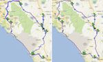
Two maps were developed showing a typical daily route through Southern California’s Inland Empire and along the Pacific shoreline. The region is a sprawling area of coastal, desert and mountainous land, populated by dense cities and towns and remote rural residences and villages. On any given day, local field service operatives can travel vast distances from one appointment to the next. The two route maps were generated using GPSTrackIt.com’s Fleet Manager software. For each route, the driver was assigned the same nine stops. The maps demonstrate the impact of Fleet Manager’s Mapping and Route Optimization features on miles driven and daily costs. On the non-optimized route (see photo, left side), the driver traveled 274 miles. The dark blue portions of the route are where the driver doubled back for his next stops. On the optimized route (see photo, right side), the driver traveled a much shorter distance of 170 miles, accomplishing the exact same nine-stop schedule in less time.
